Życzenia świąteczne 2018
Michał Wilde archiwalne


Michał Wilde archiwalne
Michał Wilde archiwalne
W imieniu dra hab. inż. Tomasza Kolerskiego z Katedry Hydrotechniki Wydziału Inżynierii Lądowej i Środowiska Politechniki Gdańskiej zapraszamy na seminarium profesora Hung Tao Shen z Uniwersytetu Clarkson w stanie Nowy Jork pt.:
WINTERTIME RIVER DYNAMICS IN COLD REGIONS
(15 i 22 pażdziernika 2018, 9:15-14:00)
oraz na seminarium profesorki Hayley Shen z Unierstytetu Clarkson w stanie Nowy Jork pt.:
WATER WAVE MECHANICS
(16 i 23 pażdziernika 2018, 9:15-14:00)
Seminaria będą przeprowadzone w Sali Rady Wydziału Inżynierii Środowiska, (sala 155) w Gmachu Głównym Politechniki Gdańskiej.
Uprzejmie prosimy o kierowanie wszelkich pytań w sprawie seminarium na adres: tomasz.kolerski@pg.edu.pl
Seminarium profesora Hung Tao Shen
WINTERTIME RIVER DYNAMICS IN COLD REGIONS
HUNG TAO SHEN
Department of Civil and Environmental Engineering
Clarkson University, USA
htshen@clarkson.edu
ABSTRACT
The presence of ice in rivers is an important phenomenon to be considered in the development of water resources in cold regions. In regions with severe winter conditions, the river regime experiences dramatic changes compared to open water conditions. Ice formation can affect the design, operation, and maintenance of water resources engineering facilities in cold regions. Major engineering concerns related to river ice include ice jam flooding, hydropower operation, inland navigation, and water transfer.
River ice phenomena involve complex interactions between hydrodynamic, mechanical, and thermal processes, as well as the ambient hydro-meteorological conditions and channel morphology. This presentation will discuss the current state of knowledge on river ice processes from freeze up to breakup, including the formation, evolution, transport, accumulation, growth, deterioration, and dissipation of various forms of ice. Many river ice phenomena can be linked to transport processes, which encompassing the entire winter ice season through different stages of the river ice evolution from freeze up to breakup. An analytical framework based on the concept of thermal and ice transport, which links all the ice processes, can provide a consistent formulation for mathematically modeling the river ice phenomena at different stages and through the winter. This analytical framework will be discussed along with theories on major river ice processes, including the transport and evolution of thermal energy and frazil ice, the formation of anchor ice on channel bed, the dynamics of surface ice transport and the associated surface ice jams formation, and the transport and accumulation of frazil granules on the underside of the ice cover and the associated frazil jam (hanging dams). In alluvial channels, the presence of river ice can cause major changes on sediment transport and channel morphology. Recent development on sediment transport with ice conditions is presented. The formation of river ice can also have significant environmental and ecological implications on the rivers. Very little is known about this aspect, although its significance has been recognized. Issues related to this will be discussed.
Hung Tao Shen jest od 1983 profesorem na Wydziale Inżynierii Lądowej i Środowiska Uniwersytetu Clarkson w stanie Nowy Jork, gdzie pełnił funkcję dziekana w latach 2010-2012, Swoje zainteresowania naukowe związał głównie z modelowaniem matematycznym zjawisk lodowych na rzekach. Jest autorem i współautorem 75 publikacji w czasopismach recenzowanych i ponad 160 artykułów konferencyjnych, które są szeroko rozpoznawane w środowisku naukowym (index Hirsha 18). Jego badania naukowe zostały uhonorowane licznymi nagrodami w tym:
Ice Research and Engineering Award, IAHR, 2008 Hunter Rouse Hydraulic Engineering Award and Lecture, ASCE, 2007 R. Larry Gerard Medal, Canadian Geophysical Union, Hydrology Section - CRIPE, 2001 & 2015 Harold R. Peyton Award for Cold Regions Engineering, ASCE, 2000 CAN-AM Civil Engineering Amity Award, ASCE, 2000
Seminarium profesorki Hung Tao Shen rozpocznie się wykładem:
SEA ICE
Hayley Shen, Research Professor
Department of Civil and Environmental Engineering
Clarkson University, USA
ABSTRACT
Sea ice covers roughly 7% of world's surface and 10% of ocean surface. They exist mostly in the polar regions far from human population. However, their impact on natural and anthropological systems is immense. Just imagine how the world will be when we have a totally ice-free Arctic in the foreseeable future. In this talk, I will give a one-person's account of how a researcher begins to study sea ice. Although only on a very specific and small part of this fascinating topic, the range of activities involved in this research shows how important it is to synthesize many tools, develop new skills, and collaborate with minds and thoughts from different perspectives, to understand and to work with the nature.
Hayley Shen jest od 1992 r. profesorem na Wydziale Inżynierii Lądowej i Środowiska Uniwersytetu Clarkson w stanie Nowy Jork. Swoje zainteresowania naukowe związała głównie z modelowaniem ośrodków rozdrobnionych oraz dynamiką lodu morskiego. Jest autorem i współautorem 5 książek, 81 publikacji w czasopismach recenzowanych i wielu artykułów konferencyjnych, które są szeroko rozpoznawane w środowisku naukowym (index Hirsha 18). Jego badania naukowe zostały uhonorowane licznymi nagrodami w tym:
Fellow, Engineering Mechanics Institute, ASCE, 2013 Kirstin Craig Memorial Faculty Award, 2004 Outstanding Advisors, Clarkson University Phalanx Award, 2001 Million Dollar Club of Clarkson University Research Accomplishment, 2001 Japan Science and Technology Agency Fellow, Hokkaido University, 1999 Albert D. Merrill Faculty Prize, Clarkson University, 1995 William Evans Fellow, Otago University, New Zealand, 1994 Walter L. Huber Civil Engineering Research Prize, ASCE, 1991 ASCE/Engineering Foundation Research Institute Award, 1984
Załączniki:
Michał Wilde archiwalne, doktoraty
Komisja Rady Naukowej ds. przewodów doktorskich - Instytutu Budownictwa Wodnego PAN w Gdańsku zawiadamia, że 9.10.2018 roku o godzinie 12.00 w sali konferencyjnej Instututu w Gdańsku-Oliwie przy ul. Kościerskiej 7 odbędzie się publiczna obrona pracy doktorskiej
mgr Magdaleny Stelli
pt. "Hydrodynamiczne i litodynamiczne przydenne procesy dalekiego przybrzeża morza bezpływowego".
| Promotor: | dr hab. inż. Rafał Ostrowski, prof. IBW PAN |
| Recenzenci: | dr hab. Tomasz Petelski, prof. IO PAN |
| dr hab. inż. Adam Szymkiewicz, prof. PG |
Z pracą doktorską można zapoznać się Bibliotece Instytutu Budownictwa Wodnego PAN w Gdańsku-Oliwie przy ul. Kościerskiej 7, w godz. 10.00 - 14.00.
Dokumenty do pobrania:
Michał Wilde archiwalne
Z głębokim żalem zawiadamiamy, że 2 maja 2018 r., w wieku 71 lat, odszedł od nas
Śp.
znakomity naukowiec i wspaniały kolega
Od roku 1970 pracownik Instytutu Budownictwa Wodnego Polskiej Akademii Nauk,
od 1998 kierownik Zakładu Mechaniki i Inżynierii Brzegów,
wybitny specjalista w zakresie inżynierii morskiej strefy brzegowej i oceanografii fizycznej,
autor lub współautor sześciu monografii naukowych i ponad 200 publikacji,
nauczyciel i wychowawca wielu cenionych naukowców.
Będzie nam bardzo brakowało jego wielkiej wiedzy, z którą chętnie się dzielił,
życzliwości i dobroci.
Rodzinie i Bliskim Zmarłego najszczersze wyrazy współczucia składają
Koleżanki i Koledzy
z Instytutu Budownictwa Wodnego PAN w Gdańsku
Msza Św. odbędzie się 10 maja 2018 r. o godz. 1000 w kościele pw. Matki Boskiej Nieustającej Pomocy na Niedźwiedniku (ul. J. Słowackiego 79).
Uroczystości pogrzebowe rozpoczną się tego samego dnia o godz. 1130 w Nowej Kaplicy na cmentarzu Srebrzysko.
Michał Wilde archiwalne
Ogłoszenie o pracy w Instytucie
Instytut Budownictwa Wodnego PAN ogłasza konkurs na 1 stanowisko profesora zwyczajnego w Zakładzie Geomechaniki
DYSCYPLINA NAUKOWA: budownictwo
DATA OGŁOSZENIA: 30 kwietnia 2018 r.
TERMIN SKŁADANIA OFERT: 30 maja 2018 r.
LINK DO STRONY: www.ibwpan.gda.pl
SŁOWA KLUCZOWE: geotechnika, geomechanika.
Do obowiązków profesora będzie należała praca naukowo-badawcza w zakresie geotechniki, udział w kształceniu młodych kadr naukowych IBW oraz uczestnictwo w projektach naukowych i pracach zleconych z przemysłu i gospodarki, realizowanych w Zakładzie Geomechaniki.
Wymagania:
Zainteresowane osoby prosimy o przesyłanie ofert zawierających list motywacyjny, CV i uwierzytelnione kopie dokumentów potwierdzających wymagane wykształcenie i kwalifikacje zawodowe pod adresem: IBW PAN, ul. Kościerska 7, 80-328 Gdańsk, z dopiskiem: "Wyrażam zgodę na przetwarzanie moich danych osobowych zawartych w ofercie pracy dla potrzeb niezbędnych do realizacji procesu rekrutacji, zgodnie z Ustawą z dn. 29.08.97 r. o ochronie danych osobowych (Dz. U. nr 133 poz. 883)."
Michał Wilde archiwalne
LiveLagoons – The use of active barriers for the nutrient removal and local water quality improvement in Baltic lagoons (Wykorzystanie aktywnych barier w celu usuwania biogenów oraz lokalnej poprawy jakości wód lagun bałtyckich) - Program:Interreg Bałtyk Południowy (Nr umowy:STHB.02.02.00-LT-0089/16-00)
![]()
Realizacja projektu rozpoczęła się w sierpniu 2017 r. i zakończy się w 2020 r. Głównym celem projektu jest zainteresowanie lokalnych społeczności Bałtyku Południowego zastosowaniem tzw. aktywnych barier do lokalnej poprawy jakości wody w rejonie kąpielisk morskich w celu stworzenia sprzyjających warunków do kąpieli w nich.
Działanie barier polega na usuwaniu biogenów z wody poprzez ich pobieranie przez system korzeniowy roślin posadzonych na tych barierach. W ramach projektu LiveLagoons planujemy przetestować dwa typy rozwiązań, tj. pływające wyspy, które będą posadowione na polskich wodach przybrzeżnych Morza Bałtyckiego, na Zalewie Szczecińskim po stronie niemieckiej oraz na Zalewie Kurońskim w Juodkrante, na Litwie. W projekt zaangażowane są gminy zainteresowane takimi rozwiązaniami oraz gmina bezpośrednio wdrażająca pilotażową instalację pływającej wyspy. Wyniki projektu będą szeroko rozpowszechniane w nadmorskich i nadzalewowych gminach, miastach, jak również instytucjach odpowiedzialnych za zarządzanie i nadzorowanie strefy brzegowej.
Link do strony projektu http://www.balticlagoons.net/livelagoons/.
Michał Wilde archiwalne
30 listopada 2017 r. odbyło się uroczyste podpisanie umowy przystąpienia do Konsorcjum Narodowego Centrum Badań Bałtyckich nowych Partnerów: Politechniki Gdańskiej, Gdańskiego Uniwersytetu Medycznego, Akademii Morskiej w Gdyni, Instytutu Oceanologii PAN w Sopocie, Morskiego Instytutu Rybackiego – PIB i Instytutu Budownictwa Wodnego PAN w Gdańsku.
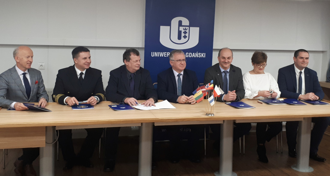 Na zdjęciu od lewej: dr hab. inż. Waldemar Świdziński (IBW PAN), dr hab. inż. Adam Olejnik (AMW), dr hab. inż. Marek Dzida (PG), prof. dr hab. Krzysztof Bielawski (UG), dr Emil Kuzebski (MIR), mgr Danuta Szkutnik (IO PAN), dr hab. Dariusz Wielgomas (GUM).
W spotkaniu udział wzięli:
Spotkanie rozpoczęto od uroczystego podpisania umowy przystąpienia do Konsorcjum Narodowego Centrum Badań Bałtyckich nowych partnerów: Politechniki Gdańskiej, Gdańskiego Uniwersytetu Medycznego, Akademii Morskiej w Gdyni, Instytutu Oceanologii PAN w Sopocie, Morskiego Instytutu Rybackiego – PIB i Instytutu Budownictwa Wodengo PAN w Gdańsku.
Michał Wilde archiwalne
W dniu 26.06.2017 w trakcie posiedzenia Konwentu Politechniki Gdańskiej zostało podpisane porozumienie pomiędzy Politechniką Gdańską, Uniwersytetem Gdańskim i Instytutem Budownictwa Wodnego PAN o współpracy na rzecz Programu Zagospodarowania Dolnej Wisły.
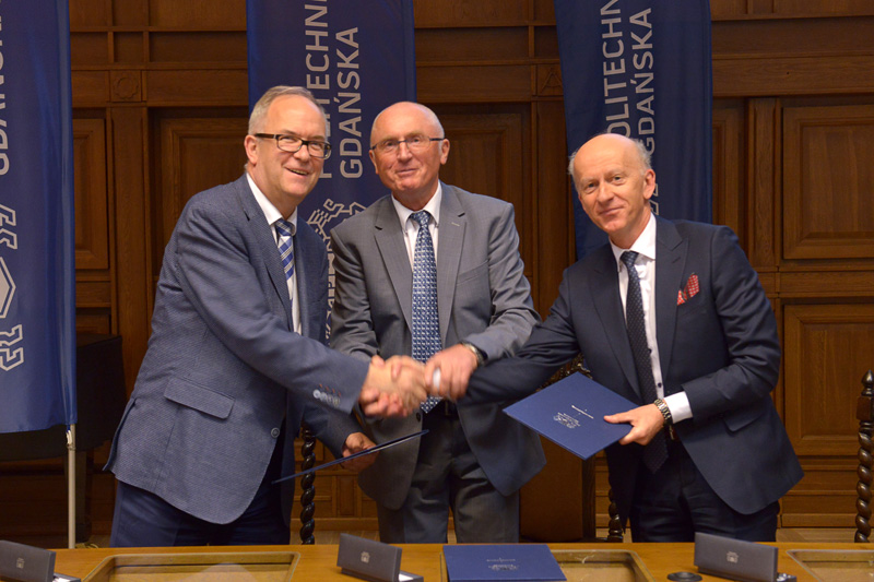 Sygnatariusze porozumienia (od lewej strony): rektor Uniwersytetu Gdańskiego prof. Jerzy Gwizdała, rektor Politechniki Gdańskiej prof. Jacek Namieśnik, dyrektor Instytutu Budownictwa Wodnego PAN prof. Waldemar Świdziński.
Dokument został podpisany w obecności przedstawicieli Ministerstw Środowiska, Gospodarki Morskiej i Żeglugi Śródlądowej, Infrastruktury i Budownictwa, Rozwoju, władz samorządowych województwa pomorskiego, parlamentarzystów, przedstawicieli biznesu oraz mediów.
Podpisane porozumienie, potwierdzające dotychczasowe osiągnięcia Instytutu, stanowi również impuls dla rozwoju potencjału naukowego - badawczego w zakresie szeroko rozumianej hydrotechniki w nadchodzących latach.
Więcej informacji na stronie Politechniki Gdańskiej
Pełna wersja porozumienia w postaci elektronicznej: porozumienie.pdf
Michał Wilde archiwalne
Podczas posiedzenia Rady Naukowej Instytutu Budownictwa Wodnego PAN w dniu 28.06.2017
wręczono Dyplom Doktorski dr inż. Aleksandrze Korzec,
nadano stopień doktora nauk technicznych w zakresie budownictwa mgr. inż. Grzegorzowi Cerkowniakowi za pracę „Dynamika stożka ujściowego Wisły w różnych skalach czasowych i przestrzennych”,
otwarto przewód doktorski mgr. inż. Marcinowi Smyczyńskiemu pod roboczym tytułem „Reakcja nawodnionych gruntów niespoistych o niepełnym nasyceniu w warunkach bez odpływu wody z porów” oraz wyznaczono dr. hab. inż. Waldemara Świdzińskiego, prof. IBW PAN na promotora pracy,
Michał Wilde archiwalne, doktoraty
Komisja Rady Naukowej ds. przewodów doktorskich - Instytutu Budownictwa Wodnego PAN w Gdańsku zawiadamia, że dnia 11.04.2017 roku o godz. 11:00 w sali konferencyjnej Instytutu w Gdańsku - Oliwie, ul. Kościerska 7 odbędzie się publiczna obrona rozprawy doktorskiej
mgr inż. Grzegorza Cerkowniaka
pt. "Dynamika stożka ujściowego Wisły w różnych skalach czasowych i przestrzennych".
| Promotor: | dr hab. inż. Rafał Ostrowski, prof. IBW |
| Recenzenci: | prof. dr hab. inż. Elżbieta Nachlik (Politechnika Krakowska) |
| prof. dr hab. Paweł Rowiński, czł. koresp. PAN (Instytut Geofizyki, Polska Akademia Nauk) |
Z pracą doktorską można zapoznać się w Bibliotece Instytutu Budownictwa Wodnego PAN w Gdańsku - Oliwie, ul. Kościerska 7, w godz. 10:00 - 14:00, a ze streszczeniem pracy i recenzjami na stronie internetowej IBW PAN.
Dokumenty do pobrania: