
Surveys at CRS Lubiatowo and selected results
Seventies (Environmental Laboratory within RWPG programmes)
The laboratory was extensively engaged for the first time in 1974 when an international experimental project “Lubiatowo-74″ was organised under the RWPG programme “World Ocean”. Research teams from Bulgaria, East Germany, Romania, USSR and a few Polish institutes took part in this campaign.
As a result, field data on the following processes were collected:
- Variability of wind speed and direction across the coastal zone,
- Spectral characteristics of hydro-meteorological phenomena,
- Surf zone currents,
- Wave transformation in the surf zone,
- Sediment concentrations and diffusive parameters,
- Water temperatures, heat balance and exchange.
The results were published as a book in English and Russian.
A similar venture was organised in 1976 as “Lubiatowo-76″. The results were extended in comparison to those of 1974. In addition, aeolian transport of sand was investigated, as well as the variability of grain size distributions in time and space, cross-shore profile evolution, micro-forms of the sea bed, wave run-up and wave orbital velocities. During this field survey, a number of researchers from west Europe and USA visited CRS Lubiatowo to get acquainted with the methods and results of the investigations.
Eighties and nineties (national research programmes)
Since eighties, surveys and measurements at CRS Lubiatowo have been concentrated on sediment transport, currents in the surf zone and dynamics of coastal morphological parameters (shoreline position and cross-shore profile features, e.g. bars). The investigations of sediment transport and coastal currents have been carried out within thematic field campaigns (concerning specific problems), while coastal morphodynamics is observed more frequently, within routine measurements. The monitoring of morphodynamics comprises shoreline position, nearshore bathymetry and topography of emerged part of the beach.
Sediment transport
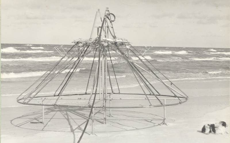
Tracer investigations were carried out during a few surveys at CRS Lubiatowo. These surveys were conducted in collaboration with the Institute of Chemistry and Nuclear Technology (Warsaw). The first ones took place in 1984. Initially, they were aimed at development of measuring techniques and methodology, then they were concentrated on some particular issues, e.g. incipient motion of single grains, critical velocity of bulk sand transport, bedload rate and thickness of the mobile layer of sandy bed. To carry out some of those field studies, a few structures were invented, called “spiders” (from the shape of the first framework used in 1984).
In the tracer experiments, use was made of iridium glass grains close in size to natural sand. The half-life period of the radioisotope (Ir-192) was 74.4 days. In general, simultaneous measurements of hydrodynamics and wind were conducted during the radio-isotopic studies. The most extensive field campaigns were carried out in 1993 and 1994. They included disposal of a number of tracer batches at different locations of the Lubiatowo coastal zone. During each campaign, tens of core samples were taken from the sea bed. The samples originated from various areas coupled with the movement of tracer plumes. The samples were analysed in 2-cm layers by the use of a very sensitive scanner. Both location and intensity of the radiotracer in plumes was measured from a boat with a special monitoring and recording apparatus.
Nearshore currents
Intensification of measurements of coastal currents in eighties and nineties was related to a great progress in measuring techniques and instrumentation. The first technologically advanced campaigns aimed at investigations of currents in the surf zone were organised in 1983 and 1986 when the INTEROCEAN current meters were used, which enabled registrations of two components of currents (cross-shore and longshore flows). The success of those campaigns gave rise to organisation of the next one in 1987. This one was the most extensive, with the use of 9 electromagnetic current meters. Some of these devices were brought to Lubiatowo by researchers from the University of Hanover. During this campaign, large data sets were collected which enabled to varify and validate theoretical models of longshore and cross-shore currents.
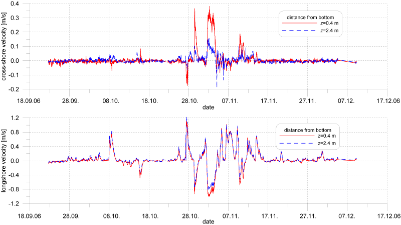
In the nineties, a great progress was done both in the theoretical description of wave-induced nearshore currents and in the accuracy of measurements in situ. This progress inspired the IBW PAN research team (of the Department of Coastal Engineering and Dynamics) to undertake a new survey devoted to currents in the surf zone. The locations of deployment of current meters were determined thoroughly in order to investigate vertical distributions of wave-driven currents at bar crest and at bar trough (bar no. II and a trough landwards of it, see Fig. 6). The measurements, during which 5 modern electromagnetic current meters were used, shed more light on the features of cross-shore and longshore water flows over a barred shore profile. The results of both campaigns of 1987 and 1996 yielded a number of publications and presentations at international conferences. The exemplary time series of nearshore currents in the surf zone of CRS Lubiatowo are plotted in Fig. 10.
Coastal morphodynamics
The very first sporadic and rough bathymetric surveys nearby Lubiatowo were carried out in the middle sixties. More precise echo-soundings, related to a stable geodetic baseline, were started in the seventies (mostly during the campaigns of 1974 and 1976). More regular bathymetric measurements, covering vast longshore and cross-shore ranges, were started in early eighties.
In 1983 the currently existing base was set up and the ongoing measurements gained geodetic compatibility. Since 1987 the bed is mapped upon predominantly bi-annual basis, once in the spring and then in the autumn. In the beginning, traditional geodetic equipment was used for boat positioning and an echo-sounder attached to a boat was utilised. Since mid 1990′s the positions of boat along each profile are controlled with a GPS device. Corrections for water level and the placement of echo-sounder in a boat are made routinely. Profile portions near the shoreline are fixed with traditional geodetic equipment.
The range of currently carried out cross-shore measurements varies from some 600 up to about 1500 m, depending on weather conditions during records, usually it covers about 1000 m. The spacing of records in a profile is kept constant about 10 m.
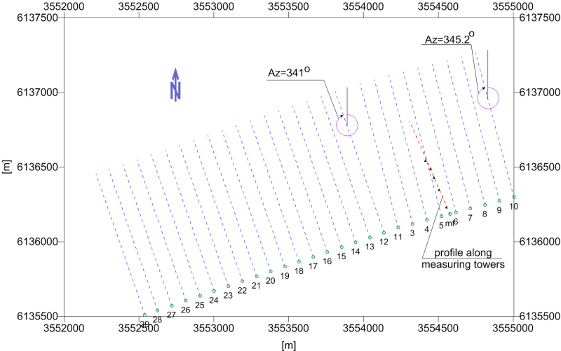
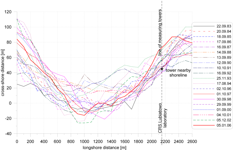
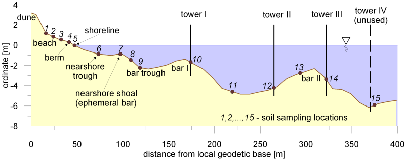
A shape of the present geodetic base is presented in Fig. 11. Initially, the points 3-10 were fixed along one line, delineating one common azimuth. Right angle intersections at those points defined cross-shore profiles along which part of bathymetry could be recorded. The currently non-existing points 0, 1 and 2, situated along the dashed elongation of this original base, retained this orientation. The initial base was destroyed during storms and was not recovered. Instead, new points 3-10 were fixed in 1983 firmly on the dune crest at locations similar yet not identical to those set up previously. Additionally, the base was extended westwards to fix the points 29-11. They have a common azimuth as well (71o), deviated by some 4o11′ from the orientation of the original base (having the azimuth of 75o). Right angle intersections at these points with this part of geodetic base yield additional 19 cross-shore profiles for nearshore bathymetry surveys. In sum, there are 27 points equally spanned every 100 m, covering the alongshore stretch of 2600 m.
In 1983, together with the establishment of current geodetic base, measurements of beach topography from shoreline to a dune were initiated. They have been taken upon approximately a monthly basis along shoreward extensions of the cross-shore bathymetric profiles. At first, traditional geodetic equipment was used for this purpose, since mid 90′s they are executed using the GPS equipment.
The records of shoreline evolution indicate the whole coastal segment is in relative equilibrium, although the records of last years appear to reveal a slight tendency towards the erosion, possibly due to the growing storminess. The greatest components of shoreline evolution time series represents variations presumably forced by long-term trends in the wave climate. As shown by thorough statistical-stochastic analyses, these trends result in slow cycles in the 20 m band, their period varies between 8 through 16 up to 25-30 years depending on particular baseline point. Minor changes represent chaotic pulsations and are believed to manifest self organised shoreline behaviour, the characteristics of which can be linked to such features as mean beach slope and average sediment grain diameter. The periods of such pulses range between 1.5 through 2 until 3-4 years, the spatial range of pulses is within 5 m. The samples of shoreline positions are shown in Fig. 12.
Other measurements
Deep water waves
Precise measurements of offshore wave motion require specialist and expensive equipment. Such measurements were possible for the first time at CRS Lubiatowo in 1989 when a few month long survey was carried out. In fact, using a wave buoy, the quasi-deep-water waves were registered, namely at the depth of about 7 m. After a loss of the buoy in middle nineties, new buoy was purchased which enabled measurements of both water surface elevations and wave direction (Directional Waverider). Since then, a few long-term offshore waves series have been measured at CRS Lubiatowo.
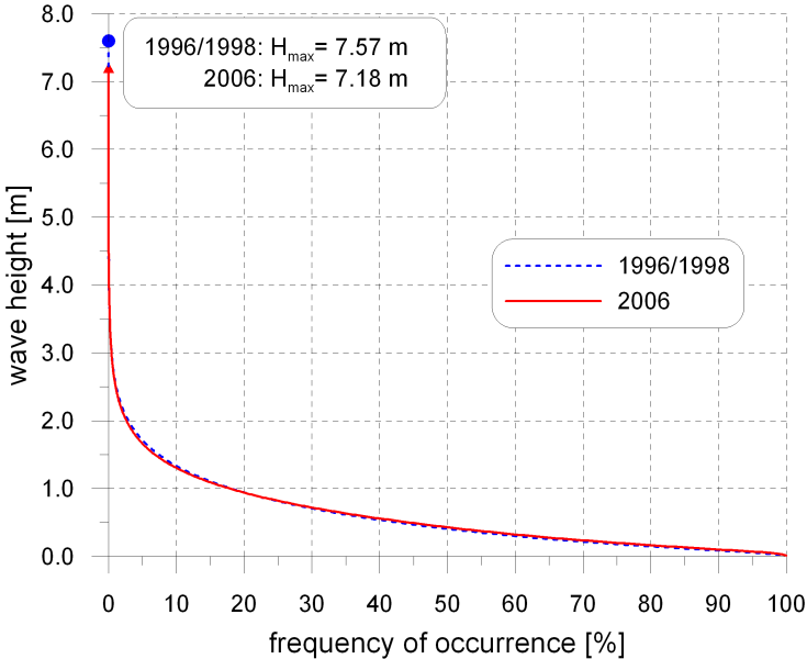
The data on deep-water wave parameters (height, period and direction) were recorded with the waverider, situated 3.5-4.5 km offshore at a depth of about 17-20 m, covering the fall of 1996, the whole 1997 and a part of 1998. Selected processed data are summarised in the Tables 1 and 2, as well as in Fig. 13.
| Hs [m] | N | NE | E | SE | S | SW | W | NW | Total |
|---|---|---|---|---|---|---|---|---|---|
| < 0.5 | 3.06 | 6.84 | 5.72 | 0.32 | 1.31 | 0.38 | 8.35 | 3.19 | 29.18 |
| 0.5-1.5 | 5.90 | 12.60 | 2.75 | 0.11 | 0.18 | 0.04 | 21.74 | 4.00 | 47.32 |
| 1.5-2.5 | 3.06 | 3.22 | 0.02 | 0.00 | 0.00 | 0.00 | 10.94 | 2.23 | 19.47 |
| 2.5-3.5 | 0.99 | 0.20 | 0.00 | 0.00 | 0.00 | 0.00 | 1.73 | 0.50 | 3.42 |
| >3.5 | 0.50 | 0.00 | 0.00 | 0.00 | 0.00 | 0.00 | 0.00 | 0.11 | 0.61 |
| Total | 13.52 | 22.86 | 8.50 | 0.43 | 1.49 | 0.41 | 42.76 | 10.03 | 100.00 |
Table 1. Characteristic deep-water wave heights measured at Lubiatowo
| Date | Hmax
[m] |
(Hs)max
[m] |
(Hs)mean
[m] |
(Hmean)max
[m] |
(Hmean)mean
[m] |
|---|---|---|---|---|---|
| October 96 | 5.68 | 3.10 | 1.48 | 2.04 | 0.92 |
| November 96 | 4.50 | 2.53 | 0.99 | 1.58 | 0.62 |
| December 96 | 6.56 | 3.67 | 1.07 | 2.30 | 0.67 |
| January 97 | 5.38 | 3.02 | 0.94 | 1.86 | 0.59 |
| February 97 | 5.64 | 3.53 | 1.39 | 2.18 | 0.86 |
| 17-31 January 98 | 7.57 | 3.79 | 1.29 | 2.30 | 0.60 |
| February 98 | 5.20 | 2.71 | 1.37 | 1.75 | 0.35 |
| March 98 | 6.09 | 3.17 | 0.96 | 2.06 | 0.37 |
| April 98 | 4.61 | 2.31 | 0.55 | 1.47 | 0.35 |
| May 98 | 3.41 | 1.72 | 0.60 | 1.09 | 0.37 |
| June 98 | 5.54 | 2.72 | 0.56 | 1.73 | 0.35 |
| July 98 | 4.43 | 2.18 | 0.71 | 1.35 | 0.44 |
| August 98 | 4.45 | 2.75 | 0.88 | 1.74 | 0.55 |
| September 98 | 3.81 | 2.02 | 0.53 | 1.30 | 0.33 |
| October 98 | 5.28 | 3.09 | 1.02 | 1.90 | 0.64 |
Table 2. Frequencies [%] of occurrence for wave classes of heights and directions
Wind
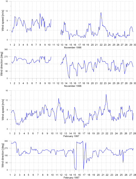
The measurements of wind parameters were started at CRS Lubiatowo in seventies and carried out during each field campaign. Since 1996 the registrations have been carried out continually every 3 hours. The wind speed and direction are measured at the height of 20 m above ground (see Fig. 14), transmitted to the laboratory and registered on PC. Each registration lasts 10 minutes. The statistical values from these series (minimum, maximum, mean, standard deviation) are computed automatically and stored (together with chosen raw data) at the IBW PAN headquarters in Gdańsk-Oliwa. The exemplary series of wind parameters are shown in Fig. 15.
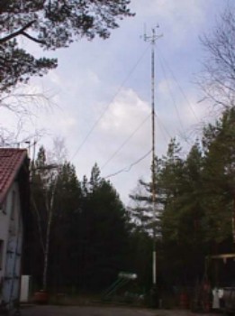
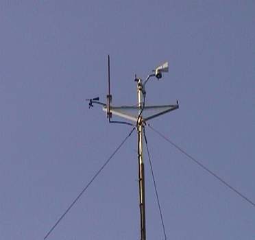
Fig. 14. Setup of wind measurements at CRS Lubiatowo
Grain size distributions
Soil sampling and grain size analyses at CRS Lubiatowo were carried out many times, most intensively during the field surveys in 1974 and 1976. Samples were taken both from the emerged part of the beach and at a number of locations on the sea bed profile. The results of analysis revealed some interesting features of grain size distributions, specific for particular locations on the cross-shore profile.
Recently, this topic has been undertaken again, which will be briefly presented in the following section.
Other experiments
Within other surveys carried out at CRS Lubiatowo on much smaller scale, one should mention investigations on the influence of sea level on groundwater at the emerged part of the beach (1972-1974), measurements of local scour at structures (piles), as well as sensing of pore pressures in the undisturbed sea bed and under a pipeline (1986), observations of cross-shore profile evolution at the shoreline (1991-1992) and wave run-up (1996).
The results obtained at CRS Lubiatowo were used in three EU projects carried out within the programme MAST III (BASYS, PACE and INDIA).
Recent surveys at CRS Lubiatowo (2000-2003)
Grain size distributions
In the period 2000-2001, regular soil samplings on the emerged and submerged parts of the beach were carried out. The investigations were aimed at identification of relationships between shoreline migration and variability of grain size distributions.
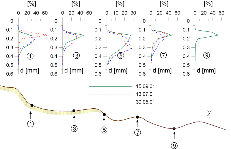
Simultaneous measurements of shoreline position, together with the topography of adjacent emerged beach, and the sediment grain size distributions in the assumed cross-shore profile were started in January 2000. In 2001, the deep water wave registration was commenced using the “Directional Waverider Buoy”. The wave measurements were taken continuously to late autumn 2001. Both the shoreline/beach variability measurements and the soil sampling were carried out monthly through the entire considered period. The monthly samplings of superficial sediment were carried out at the same morphological locations of the beach and the nearshore sea bed, as shown in Fig. 16. In addition, in the autumn of 2001, sea bed samplings were carried out three times in deeper region of the coastal zone, at locations 10-15. The deep water wave survey (wave height, period and direction) was carried out at the depth of 17 m.
The grain size distributions shown in Fig. 17 reveal significant variability of shapes across the shore profile. The sand on the beach and at the shoreline is generally coarser, with wide grain size distribution and slightly bigger asymmetry (skewness), with a shape tending to bimodality. Such features result from worse conditions for sorting, associated with very instable and turbulent forces, generated by wind, waves and currents, affecting motion of grains in this region. At the adjacent submerged beach profile (down to bar I), grain size distributions become more symmetrical and narrow (better sorting). Besides, the content of fine particles increases (d50 decreases).
The field data taken at the IBW PAN Coastal Research Station in Lubiatowo have been very helpful in verification of the theoretical findings on horizontal sorting of graded sediments and vice versa – the performed computational simulations enabled to explain and justify the behaviour of size-graded sediment observed in the experimental data. Exemplary experimental data are shown in Fig. 18.
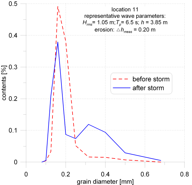
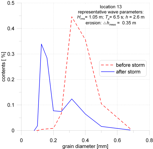
Fig. 18. Experimental data for seaward slope of the bar
Waves
Recently, there were two deep-water wave data sets collected, in 2001 and 2002, each a few months long. The presently used wave buoy has its own GPS device informing about a position of the buoy. The coordinates of this position is transmitted by radio to the receiver and registering PC at the Lubiatowo station.
The offshore waves were registered by the “Directional Waverider” buoy at h=17-20 m every hour for about 20 minutes, yielding the wave series from which statistical and spectral characteristics can be derived. From the statistical and stochastic analyses, the characteristic wave parameters are obtained. The full data series are stored in the IBW PAN database.
Currents
In 2002 another field survey in the domain of coastal currents was carried out at CRS Lubiatowo. The campaign was a part of the national research project entitled “Extension and modernisation of the mathematical model of near shore circulation on the basis of theoretical analysis and experiments”. The investigations concerned also the currents generated by sources other than wind waves.
During this two month long campaign, from 15 September to15 November 2002, the following measurements were carried out:
- deep water waves at h=20 m, about 4600 m offshore (Directional Waverider Buoy),
- nearshore waves at h=3.8 m, h=1.4 m and h=0.6 m (string wave gauges),
- currents at a crest of bar II (2 vertically aligned electromagnetic current meters), at a trough between bars I and II (Acoustic Doppler Current Profiler) and close to the shoreline at h=0.6 m (1 electromagnetic current meter), see Fig. 6 for approximate location of the bars,
- wind speed and direction,
- bathymetry from the shoreline 1000 m seawards (echo-sounding of the cross-shore transects located every 100 m in the longshore direction),
- number and features of wave breakings (visual observations),
- shoreline position every 10 m for the shore segment 2600 km long.
Coastal litho- and morphodynamics
In 2001, within the national project “Transport and sorting of sediment in a multi-bar coastal zone and its dynamics in view of theoretical analysis and experimental investigations”, the detailed survey on dynamics of grain size distributions was carried out. The measurements comprised offshore and shallow water waves, grain size distributions of sea bed samples, concentration and grain size distributions of suspended sediment, as well as variations of sea bed levels. The features of suspended sand were registered by a laser Doppler particle size analyser. Some measurements taken in 2001 are shown in one of the previous sections in comparison to the theoretical results.
Started in 2003, a two year long national project entitled “Identification and description of infra-gravity waves (edge waves) in the south Baltic coastal zone and determination of empirical relationships between generation and evolution of rhythmic coastal forms”, gave rise to a new field survey at Lubiatowo. A part of this experimental venture is presented as a demonstrative survey during the Workshop – Summer School “Coastal Zones’03″.
The field measurements comprise offshore waves and waves at shallow water, coastal currents. One current meter and one wave gauge is installed very close to the shoreline, where appearance of the edge waves is expected. Besides, a detailed monitoring of the shoreline is carried out.
The analysis of the above data will be made both by conventional stochastic-statistical tools and by more advanced and sophisticated methods like SSA (Singular Spectrum Analysis) or CCA (Canonical Correlation Analysis).
The results of the above studies, as well as of those related to transport of non-graded and graded sediments, are used as the IBW PAN contribution to the HUMOR project, ongoing within 5th Framework Programme of EU.
The history of the Coastal Research Station at Lubiatowo shows that the establishment and activity of this laboratory, unique in Poland and one of few in the world, was a very successful venture and contributed much to improvement of the knowledge on coastal zones. Existence of CRS Lubiatowo and the multi-aspect field investigations carried out in various time-spatial scales provide huge amount of data and observations of the Baltic coastal zone. This knowledge, obtained in undisturbed natural conditions, facilitates verification of many theoretical considerations and helps to understand complicated coastal physics. One can hope that the findings from CRS Lubiatowo, disseminated by reports, publications and conference presentations, have proved to be important for the Polish and international research.
CRS Lubiatowo, Poland (+48) 58 572 40 81 (tylko w nagłych przypadkach)