
Environmental conditions
The study area of CRS Lubiatowo is situated some 70 km northwest of Gdańsk (Fig. 1), and is a typical South Baltic sandy coast. Relatively mild winters, warm summers and fairly high air humidity characterise the climate at Lubiatowo. The mean air temperature is about +7.5°C and varies from -1.2°C in February to +16.5°C in July.Mean monthly water temperature varies from +1.2°C in February to +17.8°C in August. Ice at the shoreline is present for about 20 days/yr (usually from the end of January to the end of February). Water salinity amounts to 7.5 PSU during summer and 7.7 PSU in the winter. The vegetation period lasts about 200 days, usually from the beginning of April till early November. Most of precipitation, amounting to 650-690 mm/yr, is discharged in summer and autumn. Usually, there are 130 rainy days a year, the snow cover lasts about 34 days. The area is dominated by westerly and south-westerly winds, which are strongest in the autumn and winter.
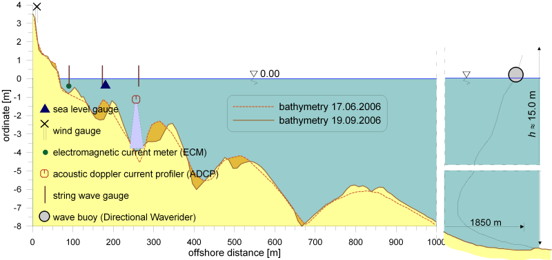
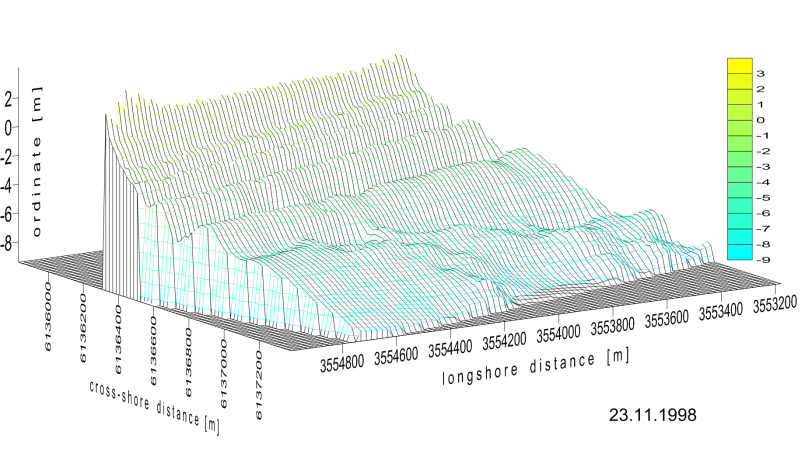
The shore in the vicinity of CRS Lubiatowo is an open and natural beach, characterised by a gentle slope (about 1.5%), with sediment diameter oscillating about the average value of d50=0.22 mm. The shore is relatively stable, although a very gentle erosive tendency has been observed over last years. The mean beach width lies between 15 and 50 m. It is bounded by dunes and featured by multi-bar cross-shore profiles, which usually show 4 stable bars (see Figs. 6 and 7) plus the ephemeral one, near the shoreline. This bar interacts with the shoreline supplying or removing the sediment and simultaneously preventing the shore from wave action. In extreme situations of storm or long calm period this bar seldom exists. In stormy conditions it is washed away by moving the material offshore and during quiet periods it moves onshore until it arrives on the shoreline. This causes the beach build-up and berm formation.
The resultant long-term wave energy flux is directed obliquely to the shoreline, thus generating eastwards directed net longshore sediment transport.
Due to existence of the bars, waves approaching the shore from deep sea are subject to significant transformation in the surf zone and most of wave energy is dissipated due to multiple wave breaking. If the deep water wave height Hs exceeds 1.5-2 m, the mean wave energy dissipated at the cross-shore profile with three offshore bars (the bars II, III and IV) amounts to about 80% of the input deep water wave energy. This denotes that in such cases not more than 20% of wave energy reaches bar I and even less reaches the shoreline proximity. For smaller height of deep water waves (Hs < 0.5-1.0 m), the amount of wave energy attaining the vicinity of bar I and the shoreline increases up to 30-50% of the deep water wave energy. In addition, because the mean wave energy flux is directed obliquely to the shore, only a part of total wave energy acts perpendicularly to the shoreline. Therefore, a small percentage of deep water wave energy attains the nearshore region and directly affects the shoreline and the beach, causing their change. By assuming generally known parameter:
![]()
where: Hb – breaking wave height,
ω – angular frequency of wave motion,
β – mean bottom slope,
one can describe a scale of dissipative processes occurring in the surf zone. CRS Lubiatowo provides its variability in the range 342 < ε < 684, which distinctly classifies the considered shore as the dissipative one.
An example showing the changes of wave height over a multi-bar bed from the initial depth of h=20 m up to h=2 m is shown in Fig. 8.
CRS Lubiatowo, Poland (+48) 58 572 40 81 (tylko w nagłych przypadkach)